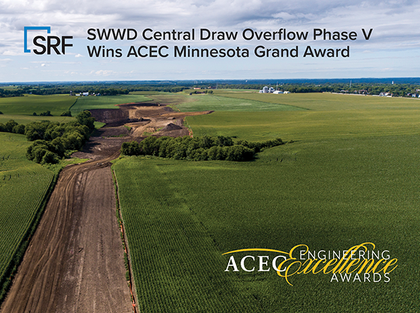
ACEC Minnesota recently recognized the South Washington Watershed District and SRF with a Grand Award for the Central Draw Overflow Phase V project! Completed in 2020, the Central Draw Storage Facility and Overflow system provides an overflow outlet to address increased development and extreme precipitation events. SRF designed the critical pipe connection for the outlet that serves a 23-square-mile drainage area. Our design included 6,200 linear feet of 72-inch RCP storm sewer at depths of five to 40 feet and 1,400 feet of stabilized channel that ties the pipe into the downstream channel system in Cottage Grove Ravine Regional Park. This resilient stormwater management system has eased fears of flooding and provides a safe, effective way to manage higher frequency storm events while allowing development to occur in a sustainable matter.
Read on to learn more about this project!
Project Introduction
One of the primary reasons the South Washington Watershed District was formed was to identify, design and construct an outlet for the District’s northern watersheds. At the time, runoff from the northern watersheds collected at Bailey Lake, which had no controlled outlet. Communities in the District recognized that Bailey Lake would not be adequate to contain all the runoff from the watershed when it was fully developed. High-intensity rainfall events are increasing in frequency, and development in the District has increased how much of that rainfall runs off the landscape. Together, these factors resulted in an existing and increasing risk of flooding that drove the need for this project.
The SWWD led a two-decade long planning effort to identify the comprehensive, combined use system known as the Central Draw Storage and Overflow system. The system provides storage and infiltration, flood protection, and public open space and leads water from the Central Draw Storage Facility (CDSF) in the City of Woodbury to the Central Draw Overflow (CDO) outfall to the Mississippi River in the City of Cottage Grove. The CDSF includes 1,800 acre feet of storage in 250 acres of publicly owned property near the outlet of Bailey Lake. A City of Woodbury lift station pumps water from Bailey Lake to the CDSF. With the size of the CDSF and rate/volume restrictions on development draining to Bailey Lake, the system should be adequate to retain the runoff from a 6.3-inch, 24-hour rainfall event. However, because of uncertainty in design, the recent trend of extreme precipitation events, and degree of safety necessary for flooding situations, SWWD began the challenging process of planning and constructing an overflow out of the CDSF to the Mississippi River.
The route for the overflow was chosen from many options explored by the District’s Technical Advisory Committee, which included technical professionals representing SWWD cities, Washington County, Washington Conservation District, and state and regional agencies. The Technical Advisory Committee selected the “cross-country” option, because it daylights the overflow to the greatest extent possible to take advantage of the high infiltration capacity of the watershed. The areas of the CDO that are daylighted also provide public benefit by incorporating native plantings and providing green space throughout the watershed.
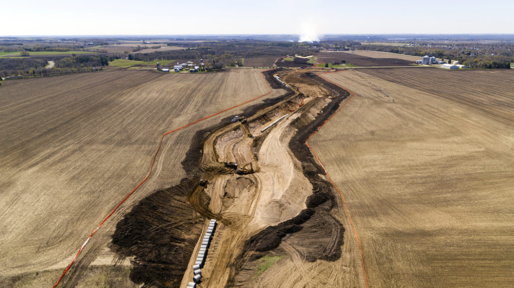
The CDO project was implemented in five phases beginning in 2013. The CDO Phase V is the last phase of the project and provides the critical pipe connection for an outlet for the approximately 23 square mile drainage area that includes portions of Lake Elmo, Oakdale, Afton, Woodbury, and Cottage Grove. The project included 6,200 linear feet of 72-inch RCP storm sewer at varying depths of five feet to 40 feet. The project also included construction of 1,400 feet of stabilized channel that ties the pipe into the downstream channel system in Cottage Grove Ravine Regional Park.
In 2018, SWWD retained SRF to prepare the final detail design plans and specifications to let the CDO Phase V construction project. On February 5, 2020, SWWD opened bids on their largest project and awarded the nearly $5 million contract to Northern Lines Contracting. The CDO Phase V project provides the SWWD communities with flood protection for events beyond the 100-year rainfall event and represents completion of a decades-long planning process for the SWWD and its partners.
Unique and/or Innovative Application of New or Existing Techniques
The planning for the CDSF and CDO resulted in an agreement between the SWWD, Valley Branch Watershed District, Denmark Township, Cottage Grove, Woodbury, and Washington County. The agreement included the following responsibilities for SWWD: requirements related to acquisition of land for the CDO, construction of improvements to CDO within Cottage Grove to accommodate limited discharge by 2014, and completion of construction of the full CDO by January 1, 2020 unless agreed to by Cottage Grove and Woodbury.
The SWWD completed construction of Phases I – IV of the CDO project between 2013 and 2017. The plan was to construct Phase V when development occurred within the parcels in the City of Cottage Grove, but the agreed to completion date of January 1, 2020 was approaching with no signs of imminent development within the Phase V area. Due to recent increased precipitation and the unknown of the timing of future development in this project area, SWWD decided to pursue property negotiations with the private landowners.
The CDO Phase V pipe alignment developed during preliminary design was set to minimize pipe depth and follow the edges of parcel lines whenever possible. During final design, SRF developed three variations of the preliminary design alignment with modifications based on the following factors and constraints: existing property boundaries, future development, existing topography, soil exploration and construction methods.
Property Impacts: The Phase V pipe alignment is in an active agricultural area and most of the parcels are owned and farmed by one family. Property owner concerns included short-term loss of crop production during and after construction, impacts on farming activities and property access, and impacts on their ability to sell/develop their parcels in the future.
Future Development: The City of Cottage Grove was in the process of updating their future land use plan as part of the 2040 Comprehensive Plan Update. The project area is expected to be primarily low-density residential land use with a small amount of commercial land use. Ravine Parkway, a major north-south roadway, is to be extended and residential collector streets are planned to provide connections from future neighborhoods. The impacted property owners expressed a desire to align the pipe with the future road as much as possible to minimize impacts to the developable land and combine public ROW into one corridor.
Topography: Existing topography in the project corridor is rolling hills accented by a natural depression at the northern end of the project and upper extent of the ravine. Impacted property owners wanted the pipe to be close to the existing depression area to minimize impact to current operations as this area is not currently farmed. This area is also planned to be a used as a regional detention basin to provide rate control and water quality treatment for future development, and the CDO will serve as the overflow for this system. The design team also considered pipe depth in the high points of the properties to minimize earth load on the pipe and minimize excavation limits for the pipe.
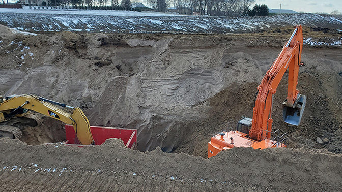
Existing Soil Conditions and Construction Methods: The project team conducted soil borings during final design. The borings from 80th Street South to the southern end of the project indicated perched groundwater above the pipe invert elevation as well as indicators of cobbles. Tunneling or jack and bore construction methods were reviewed at the 80th Street crossing to reduce impacts to land and roadway use; however, the groundwater and indication of cobbles increased the risks associated with these types of construction activities. SRF recommended using open cut construction methods for the entire pipe project to minimize risk and cost of tunneling the pipe under 80th Street. The project included a closure at 80th Street and a temporary bypass for the landowners to maintain access between fields during construction.
SRF and SWWD collaborated with the City of Cottage Grove and adjacent landowners on determining the final alignment of CDO Phase V. The resulting pipe alignment allowed farming operations to continue during construction, followed the alignment of the future residential street that will be in public ROW, minimized fill in the future north regional basin and the bisection of one parcel, balanced property impacts to multiple parcels, and reduced risk by placing the alignment in a location to use open cut construction methods.
Future Value to the Engineering Profession and Perception by the Public
This project provides a resilient stormwater management system to many communities within the SWWD. In the past decade, Minnesota has experienced several of the wettest years on record and this is expected to continue. New development is also increasing in Woodbury and Cottage Grove, resulting in significantly larger amounts of impervious surface and increased runoff in rainfall events. Woodbury’s lift station at Bailey Lake was used several times between 2005 and 2014. Since 2014, it has been used annually and discharges water to SWWD’s CDSF basin, which is upstream of the CDO. In 2019, the region experienced a large rainfall event in early spring on frozen ground and the CDSF basin filled with runoff. With construction of the final segment of pipe, the CDSF and CDO system is complete and provides an outlet during these large rainfall events. The completion of this project eases the cities and SWWD’s fears of flooding issues within the watershed and provides a safe and effective way to manage higher frequency storm events.
Social, Economic, and Sustainable Design Considerations
Planning for Future Development: A key goal of the CDSF and CDO projects was to provide a resilient, regional stormwater management solution in a watershed that was expected to experience significant growth and development. The project partners worked together to develop a system that solves the concerns of regional flooding in a land-locked basin while allowing development to occur in a sustainable matter in the communities that drain to the land-locked basin. SWWD and the project partners focused on a balanced and adaptable approach to providing regional flood mitigation and stormwater management that accounted for the future increase in stormwater runoff due to increased impervious surface and increased precipitation frequency. The SWWD worked with partners to balance the needs of requiring volume control and limiting peak discharge rates within development sites to a reasonable standard while providing the overflow system to handle extreme events and provide a path for the water if the local systems become overwhelmed.
Permitting: There is an existing public watercourse in the downstream portion of the project. The public watercourse is a ravine that starts approximately at 80th Street and continues south through Cottage Grove Ravine Regional Park to Ravine Lake. The ravine captures stormwater runoff from the surrounding drainage area but only sees intermittent flows. The public watercourse is not well-defined, but the approximate location is mapped as a public water in the Minnesota Department of Natural Resources Public Water Inventory (PWI). Approximately 2,000 linear feet of pipe was constructed adjacent to the public water course. Existing ground elevations were restored within the pipe construction limits and existing drainage conditions were maintained during construction. The outlet of the pipe daylights to a riprap basin that provides energy dissipation.
Approximately 1,400 linear feet of the ravine was modified in conjunction with the project. The ravine is designed to have 0.50 feet of freeboard during the 100-year peak flow rate. Turf Reinforcement Mat (TRM) was installed in the channel to prevent erosion and ensure a stabilized channel section. The design was based on 100-year flow rates of 150 cfs and 200 cfs obtained from XP-SWMM modeling completed during previous phases of the overall CDO project. The channel is designed to handle an increase in flow rates due to the confluence of a second branch of the ravine that combines with the project flow prior to the connection to the downstream channel.
Prior to construction, SRF reviewed offsite data sources and historical aerial photography of the project area and completed an onsite wetland review to document potential wetlands. The historical data found that wetlands and/or stream channels may be present in the project area; however, the onsite review did not find evidence of sufficient hydrophytic vegetation or wetland hydrology to indicate the presence of wetlands within the project area. Flow patterns and erosion indicative of an ephemeral stream were found to be present in the south portion of the project area, in the location of the mapped public water. SRF completed and submitted a Section 404 Permit application to the USACE for review and obtained an amendment to the previous Public Waters Work Permit from MnDNR. USACE granted the project a Nationwide Permit 43 for Stormwater Management Facilities.
Complexity
Pipe Depth and Special Design: For the CDO Phase V project, the storm sewer depths are up to 40 feet deep in some locations, which was an important consideration for design of the large diameter pipe. Depending on pipe bedding type, Class V reinforced concrete pipe can withstand earth pressures (both live and dead load) up to 33 feet deep. Due to the deeper pipe depths, a method called “D-Load” was used to design the reinforced concrete pipe. “D-Load” is a computation method for the design of reinforced concrete pipe developed by the American Concrete Pipe Association following ASTM D 76 and C 655 guidance that can be used to confirm “classified pipe” strength or to design specific pipe reinforcement for earth pressures that are greater than what Class V can withstand. SRF reviewed the D-Load factors, including bedding and trench design, to complete D-Load pipe design for the deepest segments of the pipe alignment that meets the earth pressure requirements and balanced the cost of D-Load pipe with the cost of requiring enhanced bedding requirements.
Topsoil Management: It was important to leave the disturbed agricultural areas in the same preconstruction condition after the project was completed. Construction focused on installing large storm sewer, but due to the depth and size of the pipe, there was more than 70,000 cubic yards of earth moving throughout the project. The project specifications required testing the topsoil to determine depth and nutrient levels prior to excavation, and required the contractor to submit a detailed topsoil management plan to ensure the topsoil was stripped, stored, and put back in place after the pipe was constructed. Northern Lines Contracting used double trench boxes to limit the width of excavation and limit the disturbance to existing topsoil.
Summary
Completion of the CDO Phase V project culminates the decades-long planning and implementation of a resilient and sustainable stormwater management solution for a 23 square mile land-locked watershed in SWWD’s jurisdiction. The project provides a holistic solution that meets the community’s current needs and will provide additional benefits as the community continues to develop. Together, SWWD’s system provides flood control, detention, and infiltration for 1,800 acre-feet of stormwater, 250 acres of restored prairie and space for a future learning center, trunk storm sewer for future development, restored ravine corridor and trail within an existing regional park, and stream restoration across 3M’s Cottage Grove Center.
“It is very gratifying to see this long-planned $20 million +/- project at last come to completion. Now water has a way to get from Oakdale and Lake Elmo, through Woodbury and Cottage Grove, down to the Mississippi. … Should we have another emergency (flooding), we at least know we have a top-flight flood control system in place.”
Clinton Gridley, Woodbury City Administrator