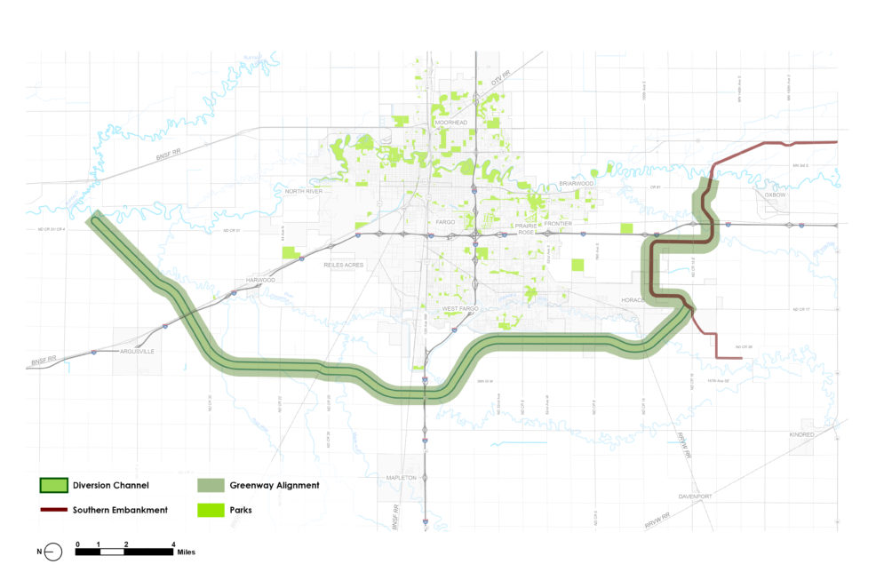
The Fargo–Moorhead (FM) Greenway represents a once-in-a-generation opportunity to create a signature regional destination for outdoor recreation while enhancing flood resilience. This 30-mile greenway will run parallel to a planned diversion of the Red River and is designed to serve both functional and community-centered purposes.
Over the last two decades, the FM area has experienced increasingly frequent and severe flooding events. Without adequate protection, future flood events could have devastating consequences for residents and businesses in the region.
Integrating Resilience, Recreation, and Economic Development
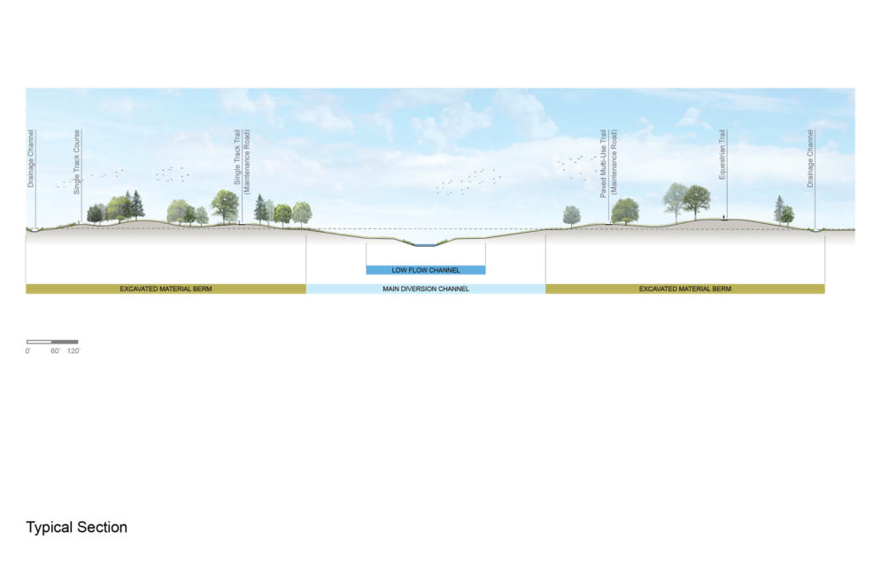
To address flood risks, the FM Metro Diversion Authority was established and now works in partnership with the U.S. Army Corps of Engineers. A core feature of the flood protection strategy is the creation of a diversion channel, supported by an earthen embankment to temporarily hold water during large flood events before releasing it downstream.
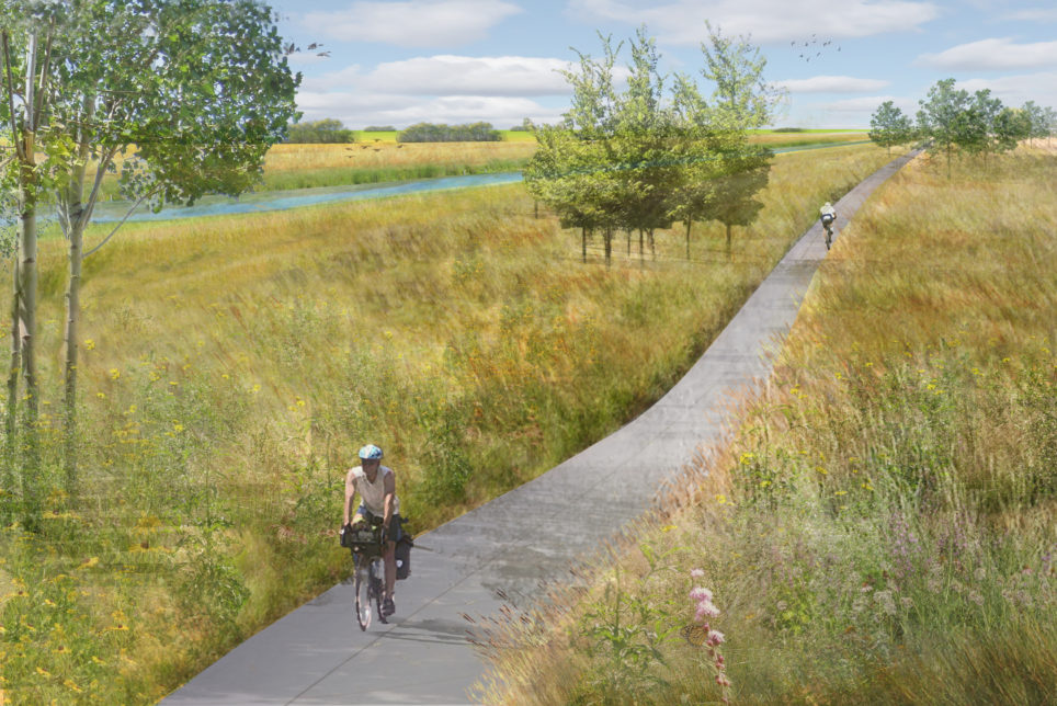
Rather than serve only a utilitarian purpose, this corridor is being reimagined as a greenway system, a year-round amenity offering trails, natural areas, cultural destinations, and public gathering spaces. Today, many FM residents travel more than 50 miles to reach regional parks. The new greenway will fill that gap with close-to-home recreation options and improve quality of life across the metro area.
SRF’s Role in Planning and Public Engagement
SRF led the Greenway Master Plan effort, guiding the full planning process from concept development to community engagement. Throughout the planning process, the project team:
- Facilitated stakeholder committee meetings
- Led public visioning events and concept ideation
- Prepared technical analyses and recreational needs assessments
- Created detailed illustrations and maps to help the public visualize the corridor’s potential
- Designed a community-first strategy that gained wide public support
A Year-Round, Multi-Use Vision for the Region
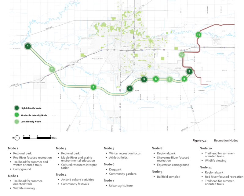
The plan responds to adjacent land uses, offering diverse recreational opportunities across different segments. High-activity nodes are located near residential and natural resource areas, while agricultural zones emphasize trails, habitat restoration, and conservation.
Recreation elements include:
- Trails for walking, jogging, biking, horseback riding, and ATV use
- Winter activities, including snowshoeing, cross-country skiing, and snowmobiling
- Nature-based amenities, including camping, fishing, and picnic areas
- Community features include urban agriculture, gardens, and athletic fields
- Cultural spaces, including seasonal festival sites, public art, and performance venues
The Greenway will support over 4,500 acres of new prairie habitat, introducing bird and pollinator corridors, and planting an estimated 9,000 trees throughout the site to restore biodiversity.
Resource Links:
Fargo-Moorhead Greenway
Fargo-Moorhead Metro Flood Diversion Authority
U.S. Army Corps of Engineers – St. Paul District
Internal Category:
Community & Transportation Planning
Community Engagement
Parks, Trails & Recreation
More from:
Fargo, ND
Minneapolis, MN
Saint Paul, MN
Community Engagement
Parks, Trails, and Recreation
Urban Design View All Projects